
Looking for a colorful, interactive map for your child or students to learn more about the USA? The Talking USA Map is a fun way to teach basic information and general knowledge about all 50 states!
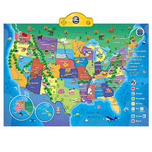
According to MaxiAids description, it is “the most valuable and educational interactive, touch-activated talking map” available on the market. The map can be hung on a wall, or children can interact with it as a colorful playmat on the floor. It features over 500 cool facts about the different states and a quiz mode to test their knowledge!
Features of the Talking USA Map:
- This map is part of ThinkGizmos Awesome Interactive Map Series which “aims to keep children learning whilst having fun”
- You can easily change the mode on the map by pressing any of the following buttons:
- Info
- Climate
- Knowledge
- Fun Fact
- Quiz
- There are also buttons to adjust the volume or have something repeated
- Comes with an easy to read instruction manual and 3 AAA batteries so you can start using it immediately
- Ideal for early learners ages five and up
- Measures 30.5 x 21 inches
Want an Interactive World Map, too? Check it out on ThinkGizmos!
Please follow and like us:
